Oil and Westernport
Click here for a great article about Westernport and the threat of oil spills
SHIPPING OIL SPILL IMPACTS ON
WESTERNPORT BAY
New research shows that Westernport Bay’s globally significant marine and coastal wetlands could
be exposed to huge damage from only relatively minor oil spills.
The Victorian Government is proposing to drastically
increase shipping capacity of the Port of Hastings in
Westernport, bringing with it an increase in shipping
traffic of fewer than 100 ships a year to more than 3000
annually.
Major dredging, land reclamation, road and rail transport
corridors through suburban Melbourne, the Mornington
Peninsula and Gippsland will also be required.
As a result the Victorian National Parks Association
and Westernport and Peninsula Protection Council
commissioned expert research into the impact of
potential oil spills on Westernport’s marine and coastal
environment due to the heightened risk of accidents
such an increase in shipping traffic will bring.
The VNPA is an independent community-based
conservation group. The Westernport and Peninsula
Protection Council has been active for 42 years.
Westernport: a remarkable
eCosYstem
Westernport is Victoria’s marine playground, a unique
tidal bay and wetland with remarkable environmental
and recreational values right on the fringe of Melbourne.
Unlike the large, deep, cold ports of the northern
hemisphere, Westernport is warm and shallow, resulting
in an exceptionally high productivity of marine vegetation
that supports a very wide range of invertebrates, fish and
marine mammals.
Phillip Island, which lies across the bay’s entrance, is
home to colonies of Little Penguins supporting a tourism
industry worth up to 1.9 billion dollars a year to the
Victorian economy.
High tides dominate water movements within the bay,
and around 40% of the area is exposed at low tide. A
natural channel exists along an ancient riverbed, but
substantial dredging was required to establish a port in
the 1960s, and further major dredging will be required
in the proposed Port of Hastings expansion to deepen
and widen the channel. There will also be large areas of
coastal land reclamation.
French Island is in the middle of the bay, and provides
refuge for large numbers of vulnerable shorebird and
migratory bird species including the Pied Oystercatcher
and Red-capped Plover. There are at least 1350 species of
marine animals living within the bay including Victoria’s
state marine emblem, the Weedy Seadragon, as well as
Pot-bellied Seahorses and dolphins. The open waters of
Westernport and approaches are also important feeding
areas for many of these animals, including the popular
Little Penguins.
The whole of the bay was listed in 1981 on the Ramsar
Convention as a wetland of international importance
and there are three marine national parks within the bay
protecting areas of especially high conservation value.
Click to set custom HTML
SHIPPING OIL SPILL IMPACTS ON
WESTERNPORT BAY PUBLISHED: August 2013
In 2002, the United Nations awarded the Westernport
region the prestigious title of a UNESCO biosphere
reserve because of its outstanding natural values.
The wide spread of the ecologically vital but sensitive
seagrass meadows, extensive tracts of mangroves and
saltmarshes, intertidal and subtidal reefs and mudflats
within the bay, coupled with strong tidal movements and
seasonal wind patterns, makes it especially vulnerable to
oil spills.
FeDerallY lIsteD speCIes
The proposed port expansion in Westernport will require
federal approval under the Environment Protection and
Biodiversity Conservation Act 1999 (EPBC), because the
bay and its intertidal shorelines are listed as Ramsar
wetlands.
These are wetlands of international importance and
provide roosting, feeding and breeding habitat for a
number of waterbird species, 32 of which are listed
under the Act. There are seven fish species that are
listed under the Act, including for example the Pipefish,
seahorses and School Sharks as well as six marine
invertebrate species including the Stalked Hydroid at
Crawfish Rock and Ghost Shrimps.
There are essentially four levels of assessment under
national environmental laws. These include:
• Assessment on referral information with the decision
made based on submitted or requested information.
• Assessment by a public environment report, which is
shorter than an Environmental Impact Statement but
has public consultation.
• Assessment by Environmental Impact Statement, which
is a more thorough assessment completed by the
project proponent.
• Assessment by public inquiry, which is the most
comprehensive form of environmental assessment.
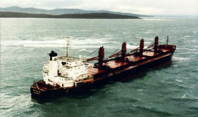
rIsk oF InCreaseD shIppIng
All shipping traffic entering Westernport and navigating
the channel carries substantial loads of oil either as fuel
or cargo. Shipping activities, particularly an international
container port, bring with them the potential for oil spills
due to collisions, ship groundings, fuel transfer spills or
other accidents.
Between 1970 and 2012 there were 27 oil spills in
Australia, including the 1995 MV Iron Baron disaster on
the Tasmanian coast, which spilt 325 tonnes of bunker
fuel oil. Despite the relatively small amount of oil spilt,
the impact on wildlife and beaches was extensive, with
an estimated total kill of Little Penguins from oil pollution
being between 7000 and 17,000.
stuDY methoD
The consultants that conducted this research, Asia-Pacific
Applied Science Associates (APASA), are the leading
oil spill modelling consultants in Australia for industry,
government and Marine Safety Victoria.
This study updates and confirms the results of past oil
spill modelling work including research commissioned by
a local group, the Westernport and Peninsula Protection
Council.
The oil spill modelling used a SIMAP three-dimensional
spill trajectory and weathering model, which is designed
to simulate the transport, spreading and weathering
of specific oil types under the influence of changing
weather conditions and ocean movements to determine
potential exposure to the bay’s environmental assets.
This model has been applied widely in Australia and
other countries to assess risks associated with oil
handling operations, support oil spill response and to
hind-cast the outcomes of real spill events.
The six oil spill scenarios used are credible and
considered conservative compared with the magnitude
of many spills that have previously occurred from
shipping operations in Australian waters and elsewhere.
Four scenarios were used to model spills of 200 metric
tonnes of heavy fuel oil from McHaffie’s Reef and Long
Point Jetty as well as two scenarios of 66 metric tonnes
diesel spills from Long Point Jetty. Two seasons were
chosen for both locations because of the predominance
of offshore northerly winds during winter and onshore
southerly winds during summer.
As shown in the map of Westernport, McHaffie’s Reef
runs under the shipping channel close to the western
entrance to the bay. Long Point Jetty is an existing jetty in
the northern part of Westernport, where a major part of
the port expansion is likely to occur.
Over one hundred replicate simulations were completed
for each combination of spill scenario and season.
Simulations were run for 14 days from the spill start
times to allow ample time for oil to migrate and
redistribute within the study area due to the influence of
tides and winds.
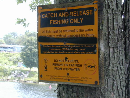
The value of Westernport for fish alone is worth protecting
Practice run starts a day late
An oil spill response operation was held winter 2012 called "Operation Sea Dragon".
It was run by AMS (Australian Marine Services) in conjunction with the Port of Hastings and The Government.
The weather was so bad that the 1st day was pretty much aborted! Bad luck if it had been a real spill, eh?
It was run by AMS (Australian Marine Services) in conjunction with the Port of Hastings and The Government.
The weather was so bad that the 1st day was pretty much aborted! Bad luck if it had been a real spill, eh?
IRON BARRON OIL SPILL BASS STRAIT
The second Iron Baron Report - implications for Westernport
The Report: "The response to the Iron Baron oil spill: Report of the Review Group" (RRG) was received by us in the week ending 9 February 1996.
In this Report the response to the Iron Baron oil spill is presented throughout as if it had been successful, with only some minor matters to be corrected or improved upon. The Report states in the Introduction: "The response to this incident indicated that arrangements established under the parameters of the National Plan worked well. There was effective leadership and management of the response by the On-Scene Co-ordinator Captain Charles Black and his team".
However, the hard information contained in this report, read in conjunction with the Report: "Navigation Act 1912, Navigation (Marine Casualty) Regulations Departmental Investigation into the grounding of the vessel bulk carrier Iron Baron on Hebe Reef, Northern Tasmania on 10 July 1995" (RDI) released by the Department of Transport in December, gives a very different picture and has significant environmental implications for Westernport.
The simple facts recorded in the two reports are as follows:
{ the vessel was carrying 596.5 tonnes of bunker and diesel oil (RDI).
{ 25 tonnes (RRG) or 40 tonnes (RDI) were removed from the ship whilst it was grounded.
{ 50 - 70 tonnes was transferred within the vessel from ruptured tanks to secure tanks (RRG).
{ 300 tonnes were estimated to have leaked from the ship whilst it was on the reef (RRG)
{ 25 tonnes leaked during refloating (RRG).
{ 7.5 tonnes was picked up by booms and skimmers (RRG) during refloating.
{ oil came ashore in a number of places en route to the scuttling ground.
{ diver examination showed that all the fuel tanks were breached.
{ "Although most of the vessel's 543 tonnes of heavy fuel oil and 53.5 tonnes of diesel fuel had escaped, it was estimated that about 70 tonnes of heavy fuel oil still remained in the damaged double bottom tanks, about 40 tonnes of which were recovered [see above]" (RDI).
{ dispersants were tried but were completely ineffective (RRG).
It appears likely from this evidence that the majority of the original load - perhaps all but the 25 (or 40?) tonnes removed and the 50 or 70 tonnes relocated on the vessel - escaped into the sea and onto the shoreline of the north coast; and whatever did not escape went into the sea at scuttling. The only oil recovered using the major response tool - booms and skimmers - was 7.5 tonnes. This amounts to 1.3% of the original load of 596.5 tonnes, or 2.3% of the 325 tonnes reported to have been spilt.
Since more oil was undoubtedly lost during towing, 2% would seem a reasonable estimate of the proportion of spilt oil recovered, far worse than the Exxon Valdez case where 7% was recovered. The National Plan response was thus 98% ineffective. It can only be regarded as a complete failure.
The reasons for low recovery were completely predictable (references are to paragraph numbers in the Report of the Review Group):
"146. The Iron Baron casualty once again demonstrated that, in rough seas, existing technology is ineffective and the fate of the oil is uncontrollable. In such conditions, an oil slick will invariably break up at sea or end up on the shore."
"155. There was a two hour delay in AMSA being notified of the Iron Baron grounding."
101. Delivery of equipment from AMOSC into the water took 21.5 hours.
"177. Weather conditions prevailing at Hebe Reef at the time of grounding precluded 'booming off' the Iron Baron. High tidal stream conditions and the reef itself would have made boom deployment dangerous and ineffective."
"179. .......Booms were of limited value in containing the oil under adverse weather and strong tidal conditions...........Oil passes under booms when currents exceed 3/4 knot."
"180. ........during the refloating ....... of the 25 tonnes released, 7.5 tonnes was recovered."
"182. The offshore response planning for refloating included 'booming' of the Iron Baron. However, due to the strong tidal stream, proximity to the reef and lack of suitable craft to handle the boom (tugs and workboats were involved with he refloating operation), the decision was made not to boom the ship. ........."
"183. Booms were only of limited value offshore because of weather and tidal conditions. In the river they had extremely limited value due to the high tidal streams. ..........."
"184. In most cases of near shore ship-sourced spills, oil ends up stranded on shore. The majority of response effort will be directed towards shoreline clean-up."
The Departmental Investigation into the grounding makes it clear that the accident occurred as a result of human errors. These do not depend on place but can happen anywhere.
Any objective assessment of the findings of the two reports taken together and applied to the enclosed waters of Westernport, where the shoreline is never more than 2 or 3 km from the channel, and where tidal streams are well in excess of 0.75 knots, would indicate that even an Iron Baron scale spill could not be responded to effectively.
If recovery were only 2%, the result of a major spill from a tanker in Westernport would be the unrecoverable deposition in the mangroves and seagrass meadows of about 98% of the oil spilt - perhaps 10,000 tonnes of oil if one or two tanks were ruptured.
The findings are thus a verification of the warnings which have been sounded for Westernport, warnings which have been fully supported by several independent and reputable consultants. Important among these are the VIMS trajectory modelling studies which flesh out scenarios many times worse than the Iron Baron outcome.
Brian Cuming
13 February 1996
Post Script 1999: See Tasmanian Department of Primary Resources, Water and Environment 'Report on the Environmental Impacts of the Iron Baron Oil Spill July 1995: Long Term Environmental Impact and Recovery' 1999. One of the important findings was:
'Despite the relatively small amount of oil spilt by the Iron Baron, the impact on wildlife was extensive. The estimated total kill of little penguins in south eastern Bass Strait from oil pollution was between 7,000 and 17,000.'
set custom HTML
WPPC Submission by Dr Brian Cuming
Submission
to the
House of Representatives Standing Committee on
Transport, Communications and Infrastructure
on their Inquiry into the Auditor-General's Audit Report No 9:
"Is Australia ready to respond to a major oil spill?".
August 1995
prepared by
Brian Cuming, MSc, PhD
President, Westernport and Peninsula Protection Council Inc.
Background
WPPC Inc
The Westernport and Peninsula Protection Council is a community conservation group formed in 1970 in response to the threat of increasing industrial port activity in Westernport Bay, and the consequent risks to its unique and sensitive ecosystems.
Reasons for submission
We have a number of reasons for making this submission:
v Our group, in association with other local and peak groups, has been concerned about oil handling in Westernport for 25 years. Since 1992 we have been particularly involved with the Shell-Mobil Crib Point proposal, and in the process have developed a considerable understanding of the national oil spill plan, of world technology for prevention and response, of the effects of oil spills, and of organisational aspects of oil spill preparedness. We have participated in a number of state and commonwealth inquiries and processes, including the presentation of substantial submissions to the House of Representatives Standing Committee on Environment and Conservation (Sub-Committee for Oil Spills Inquiry) in 1978 , and contributed to Environment Victoria's submission to the ANAO inquiry 1994 . Two of our members have visited Alaska to learn about the Exxon Valdez disaster and continue to communicate with scientists there about long term effects of the spill. Last year we sent a representative to the Spillcon conference in Perth, and in 1995 contributed to a Westernport seminar conducted by the Victorian EPA, and a forum on maritime accidents and pollution held in Melbourne by ANZECC. As a result of all of these activities, we believe we are closely in touch with the focus of the ANAO study, and can contribute usefully to the Standing Committee's inquiry.
v We wish to endorse the concerns ANAO have highlighted in their report about the state of Australia's preparedness for a major spill and the broad thrust of their criticisms of AMSA and the national plan.
v We wish to recommend that the Standing Committee's inquiry should go beyond the scope of the ANAO report and address prevention as well as response, including the consideration of alternative port and shipping arrangements, where relevant, to minimise risk.
v We believe we can offer the inquiry useful inputs from the perspective of a particular, major port about the question: "Would the National Plan work for a major spill - in Westernport - anywhere?".
v From our networking we can offer some conservation perspectives which may not be otherwise available.
Westernport Bay
Westernport is narrow and highly tidal, approximately 40% of its area being intertidal mudflats which form the basis of a highly productive and diverse ecosystem. As well as the well known colonies of penguins and Australian fur seals, the bay is host to thousands of marine species, a breeding ground for ocean fish, and the summer feeding ground for about 35 species of migrant wader birds from Siberia, China, Japan and Alaska. Almost the entire area of the bay is listed as a Ramsar wetland, and it is the largest Ramsar site in Victoria. Many of the bird species listed in the JAMBA and CAMBA agreements use the bay.
The ecological significance and the sensitivity of Westernport were brought to public attention in the 1970's by a major environmental study , and an up to date summary of that study and of subsequent work is contained in the Westernport Bay Strategy 1992 .
Oil and Westernport By Karri Giles and Dr Brian Cuming for WPPC
Oil and Westernport
What would happen if there was an oil spill in Westernport Bay? How do you clean up a bay that is so shallow that 42% of it is exposed mud-flats on each low tide. These mud-flats are covered in seagrass and embedded with molluscs and polychytes and are so soft you sink up to your waist if you tread on them. Digging up seagrass would be an ecological disaster in itself.
Mr. P McGrath, Chief Executive of AMSA, stated at Spillcon 94:"other than in exceptional circumstances, current technology does not exist to prevent weather driven oil from an inshore incident coming ashore on the coastline." Westernport consists of narrow, tidal waterways around two islands, so that a ship must always be within 2 to 5 km of a coastline. Much of the time there is "weather", so current technology does not exist to save Westernport from a moderate or major spill. A moderate (say 550 tonnes) Or major (10,000 tonnes) spill would be catastrophic, and once deposited, more damage would be caused by attempted removal.
"What is the risk of a major oil spill?" . To quote ANAO: "As AMSA says, 'It is only a matter of time'. The remarks made in the second and third paragraphs of this section are all especially relevant to Westernport: "Oil may be ingested by marine and animal life and the toxic chemicals in oil, and dispersants used to treat the oil, can have a significant ecological impact. This is a particular problem in mangroves, seagrass, and reef areas where it is difficult to remove the oil."….."Spilled oil can have a serious economic impact on coastal activities such as tourism and the fishing industry."
The two principal oil-spill response tools will be generally unavailable in Westernport."The National Plan Review identified that swift currents and high tidal velocities severely limit the opportunity for physical response (use of booms and skimmers) throughout Torres Strait and Northern Territory waters." These conditions also apply in Westernport, where tides run at up to 5 knots along the narrow arms of the bay. These conditions render the use of booms largely ineffective. Dispersant should also be regarded as generally unacceptable in Westernport, due to its toxicity. 3. Audit Report No. ("Is Australia ready to respond to a major oil spill?") ANAO, 1994 p xiii
See Sixty minutes report Crude Solutions about toxicity of dispersants.